> ## Documentation Index
> Fetch the complete documentation index at: https://sunpeak.ai/docs/llms.txt
> Use this file to discover all available pages before exploring further.
# Map
> An interactive map with points of interest, location data, and detailed inspector view.
 ## Overview
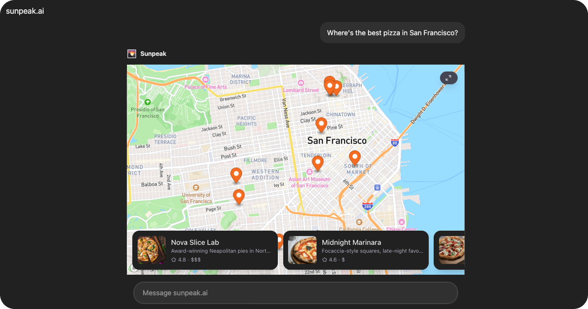
`Map` is a production-ready map resource included in the sunpeak framework. It displays pizza restaurants on an interactive map with list and carousel views, switching between inline and fullscreen display modes for different browsing experiences.
The resource retrieves place data from `useToolData().output` and manages selection state with `useAppState()`.
## Data Structure
### MapData
The resource expects data in the following format via `useToolData().output`:
```tsx theme={null}
interface MapData {
places: Place[]
}
interface Place {
id: string
name: string
coords: [number, number]
description: string
city: string
rating: number
price: string
thumbnail: string
}
```
Array of place objects to display on the map and in lists.
Unique identifier for the place.
Restaurant name displayed in cards and on the map.
Geographic coordinates as `[longitude, latitude]` for map positioning.
Brief description of the restaurant and its offerings.
Neighborhood or city area where the restaurant is located.
Restaurant rating, typically on a scale of 1-5.
Price range indicator (e.g., "\$", "\$\$", "\$\$\$").
URL to the restaurant's thumbnail image.
## Display Modes
The Map resource has two display modes:
### Inline Mode (Default)
Displays a map view with a bottom carousel of place cards. Features include:
* Interactive map with place markers.
* Horizontal scrolling carousel at the bottom.
* Fullscreen button in the top-right corner.
* Fixed height of 480px.
### Fullscreen Mode
When the user clicks the fullscreen button or selects a place, the resource:
1. Requests fullscreen mode via `useDisplayMode()`.
2. Displays a sidebar list of places (desktop).
3. Shows a detailed inspector panel when a place is selected.
4. Includes suggestion chips for filtering (desktop only).
5. Adjusts height based on available screen space.
## State Management
The resource uses `useAppState()` to persist the selected place across sessions:
```tsx theme={null}
interface MapState {
selectedPlaceId?: string | null
}
```
When transitioning from inline to fullscreen mode, the selection is cleared to provide a fresh browsing experience.
## Features
### Interactive Map
Displays an interactive map powered by Mapbox with clickable place markers and smooth pan/zoom controls.
### Multiple View Modes
Adapts the interface based on display mode:
* **Inline**: Bottom carousel for quick browsing
* **Fullscreen**: Sidebar list with detailed inspector panel
### Place Selection
Clicking a place in the carousel, list, or map updates the selected place and displays detailed information in fullscreen mode.
### Safe Area Support
Wraps content in the `` component, which automatically applies device safe area padding and viewport height constraints.
## Common Use Cases
* Restaurant finders
* Location-based service discovery
* Store locators
* Venue browsing with geographic context
* Point-of-interest exploration
## Overview
`Map` is a production-ready map resource included in the sunpeak framework. It displays pizza restaurants on an interactive map with list and carousel views, switching between inline and fullscreen display modes for different browsing experiences.
The resource retrieves place data from `useToolData().output` and manages selection state with `useAppState()`.
## Data Structure
### MapData
The resource expects data in the following format via `useToolData().output`:
```tsx theme={null}
interface MapData {
places: Place[]
}
interface Place {
id: string
name: string
coords: [number, number]
description: string
city: string
rating: number
price: string
thumbnail: string
}
```
Array of place objects to display on the map and in lists.
Unique identifier for the place.
Restaurant name displayed in cards and on the map.
Geographic coordinates as `[longitude, latitude]` for map positioning.
Brief description of the restaurant and its offerings.
Neighborhood or city area where the restaurant is located.
Restaurant rating, typically on a scale of 1-5.
Price range indicator (e.g., "\$", "\$\$", "\$\$\$").
URL to the restaurant's thumbnail image.
## Display Modes
The Map resource has two display modes:
### Inline Mode (Default)
Displays a map view with a bottom carousel of place cards. Features include:
* Interactive map with place markers.
* Horizontal scrolling carousel at the bottom.
* Fullscreen button in the top-right corner.
* Fixed height of 480px.
### Fullscreen Mode
When the user clicks the fullscreen button or selects a place, the resource:
1. Requests fullscreen mode via `useDisplayMode()`.
2. Displays a sidebar list of places (desktop).
3. Shows a detailed inspector panel when a place is selected.
4. Includes suggestion chips for filtering (desktop only).
5. Adjusts height based on available screen space.
## State Management
The resource uses `useAppState()` to persist the selected place across sessions:
```tsx theme={null}
interface MapState {
selectedPlaceId?: string | null
}
```
When transitioning from inline to fullscreen mode, the selection is cleared to provide a fresh browsing experience.
## Features
### Interactive Map
Displays an interactive map powered by Mapbox with clickable place markers and smooth pan/zoom controls.
### Multiple View Modes
Adapts the interface based on display mode:
* **Inline**: Bottom carousel for quick browsing
* **Fullscreen**: Sidebar list with detailed inspector panel
### Place Selection
Clicking a place in the carousel, list, or map updates the selected place and displays detailed information in fullscreen mode.
### Safe Area Support
Wraps content in the `` component, which automatically applies device safe area padding and viewport height constraints.
## Common Use Cases
* Restaurant finders
* Location-based service discovery
* Store locators
* Venue browsing with geographic context
* Point-of-interest exploration